📖 Our methodology
Overview
This page explains how Searoutes calculates CO₂e emissions across all supported transport modes. It details:
- The standards and frameworks we follow (GLEC, ISO 14083)
- The emission scope covered (Scope 3, Well-to-Wheel)
- The modeling logic per transport mode
- The data sources and assumptions used in our APIs
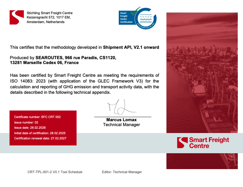
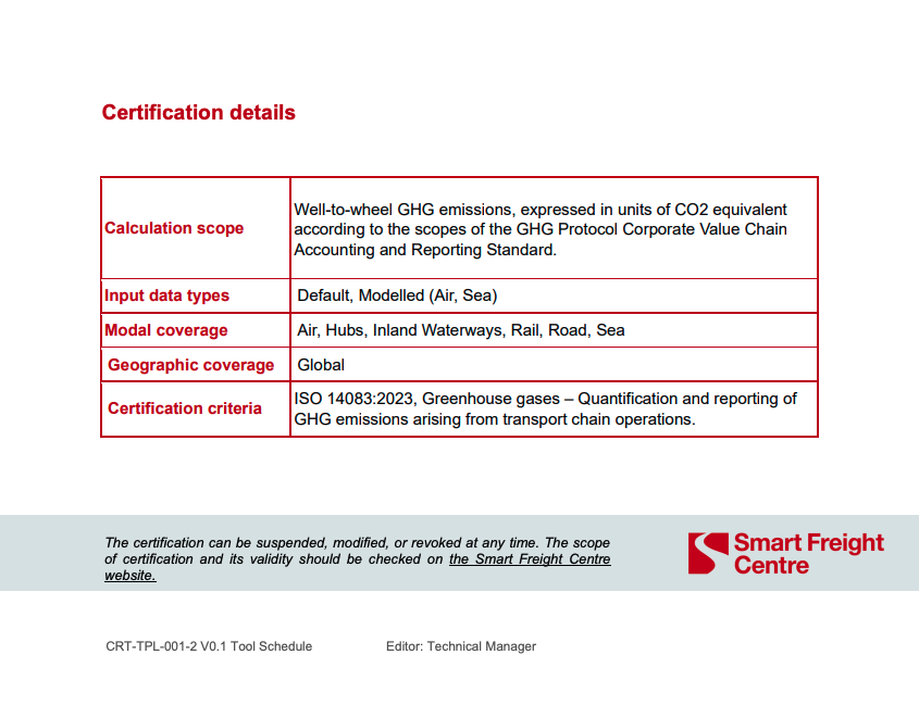
Searoutes’ calculation engine is accredited by the Smart Freight Centre for compliance with the GLEC Framework as well as ISO 14083.
Standards & accreditation
Searoutes’ calculation engine is accredited by the Smart Freight Centre. Our methodology complies with:
- GLEC Framework (v3)
- ISO 14083:2023
Certification scope includes:
- Well-to-Wheel GHG emissions
- Global geographic coverage
- Air, Sea, Road, Rail and Inland Waterways
- Default and modelled data approaches
The methodology applies to all Freight Emissions solutions, Shipment API (v2.1 and v3).
Emission scope
Scope covered
Searoutes APIs calculate transport-related greenhouse gas emissions (CO₂e) across the value chain (Scope 3), as defined by the GHG Protocol.
The results represent indirect supply chain emissions generated by the movement of goods, covering both upstream (from suppliers to the reporting company) and downstream (from the reporting company to the end customer) logistics flows.
Note: the classification of a shipment as upstream or downstream depends on the reporting company’s accounting boundary.
Well-to-Wheel approach
All results are expressed in CO₂e and include WTT and TTW, ensuring full life-cycle transport emissions reporting.
- Well-to-Tank (WTT): extraction, production and distribution of fuel
- Tank-to-Wheel (TTW): fuel combustion during transport
Modeling principles
Our approach is based on one core principle: use the most granular operational data available, and expose it through a simple API. Whenever possible, Searoutes prioritizes:
- Asset-specific modeling (e.g., vessel IMO, flight number, etc.)
- Real route distances instead of theoretical distances (e.g., historical distances for a given vessel).
- Operational constraints (ECA zones, passages, draft limits)
- Mode-specific fuel types and engine logic
When specific data is unavailable, GLEC-compliant default models are applied.
| 🚢 SEA | ✈️ AIR | 🚚 ROAD | 🚄 RAIL | 🛥️ INLAND WATERS | |
|---|---|---|---|---|---|
| SFC Accredited | ✅ | ✅ | ✅ | ✅ | ✅ |
| Calculation model | Modelled & default | Modelled & Default | Default | Default | Default |
| Asset Coverage | + 10,000 vessels | +170 aircrafts and +400 000 flight numbers | 12 Trucks categories | 7 vessels types | |
| Distances | Routes based on historical AIS, as well as carrier schedules and proformas. | Great Circle | Road network | Rail network | Routes based on AIS |
| Regions Coverage | Worldwide | Worldwide | Worldwide | Worldwide | Europe, North America, China |
| Fuel Types | HFO, VLSFO, ULSFO, MDO, MGO, LNG, BIOLNG, LSMGO, Methanol, Biomethanol, IFO380, UCO, Methanol Coal, Methanol Gas, Methanol renewables. | Kerosene | Diesel, CNG, LNG, HVO, Electric, BioLNG, BioCNG, Biodiesel and its multiple blends. | Diesel, Electric | Diesel |
| 🍶 Searoutes' Special Sauce | Actual vessel trajectories, distances and speeds, passages & ECA zones, IMO-specific, vessel engine specific. | All flight phases, Aircraft IATA specific, flight routes and aircrafts based on flight numbers. | Seamless integration of the location of cities, zip codes and addresses. | Seamless integration of the location of cities, zip codes and addresses. | Actual distances and draft restrictions. |
*some modes are using different emission factors according to the region.
Philosophy
Transport accounts for 23% of global GHG emissions and freight emissions are expected to grow significantly without intervention.
Searoutes’ objective is to make high-quality emissions data accessible, operational and decision-ready. Our APIs are designed to integrate directly into procurement, planning, and reporting workflows.
Further, our estimations include the full fuel life cycle, comprised of well-to-tank (WTT), the emissions to extract, produce and deliver energy, and tank-to-wheel (TTW), the emissions caused to move the vehicle.
Searoutes' approach to CO₂e calculations is to make use of the most granular data possible for estimations, and expose an easy to use API.
| Data Input | 🚢 SEA | ✈️ AIR | 🚚 ROAD | 🚄 RAIL | 🛥️ INLAND WATERS |
|---|---|---|---|---|---|
| Required | From, To* | From, To* | From, To* | From, To* | From, To* |
| Optional | Date, Vessel IMO or name, Carrier scac, # Containers, container sizes and types, Load Weight, Fuel type | Aircraft IATA Code, Load Weight | Fuel Type, Truck Size, # Containers, container sizes and types, Load Weight | Fuel Type, # Containers, container sizes and types, Load Weight | Barge Type, # Containers, container sizes and types, Load Weight |
*(UNLOCODE or coordinates)
Partners
The following partners provide data sources that enrich Searoutes’ transport models and improve coverage and accuracy.
- OHB Luxspace — AIS vessel positioning data used for route reconstruction and emissions modeling.
- Bluewater schedules — carrier schedules and service structures used to model real maritime routes and model emissions based on actual vessel fleets.
- Cirium — flight schedules and aircraft information used to model air transport emissions based on flight operations.
References
Our main references for the methodology below include:
- GLEC Framework version 3.2
- ISO 14083:2023
- Third and Fourth IMO GHG Study (2020)
- EMEP/EEA Air Pollutant Emission Inventory Guidebook (2019)
Updated about 2 months ago