📖 Our methodology
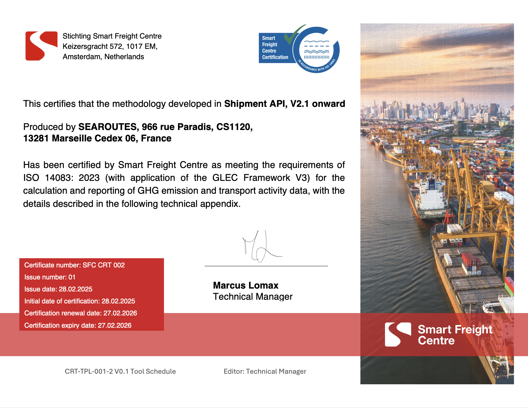
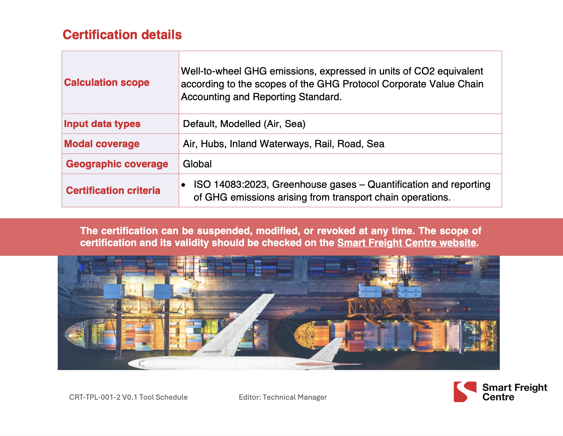
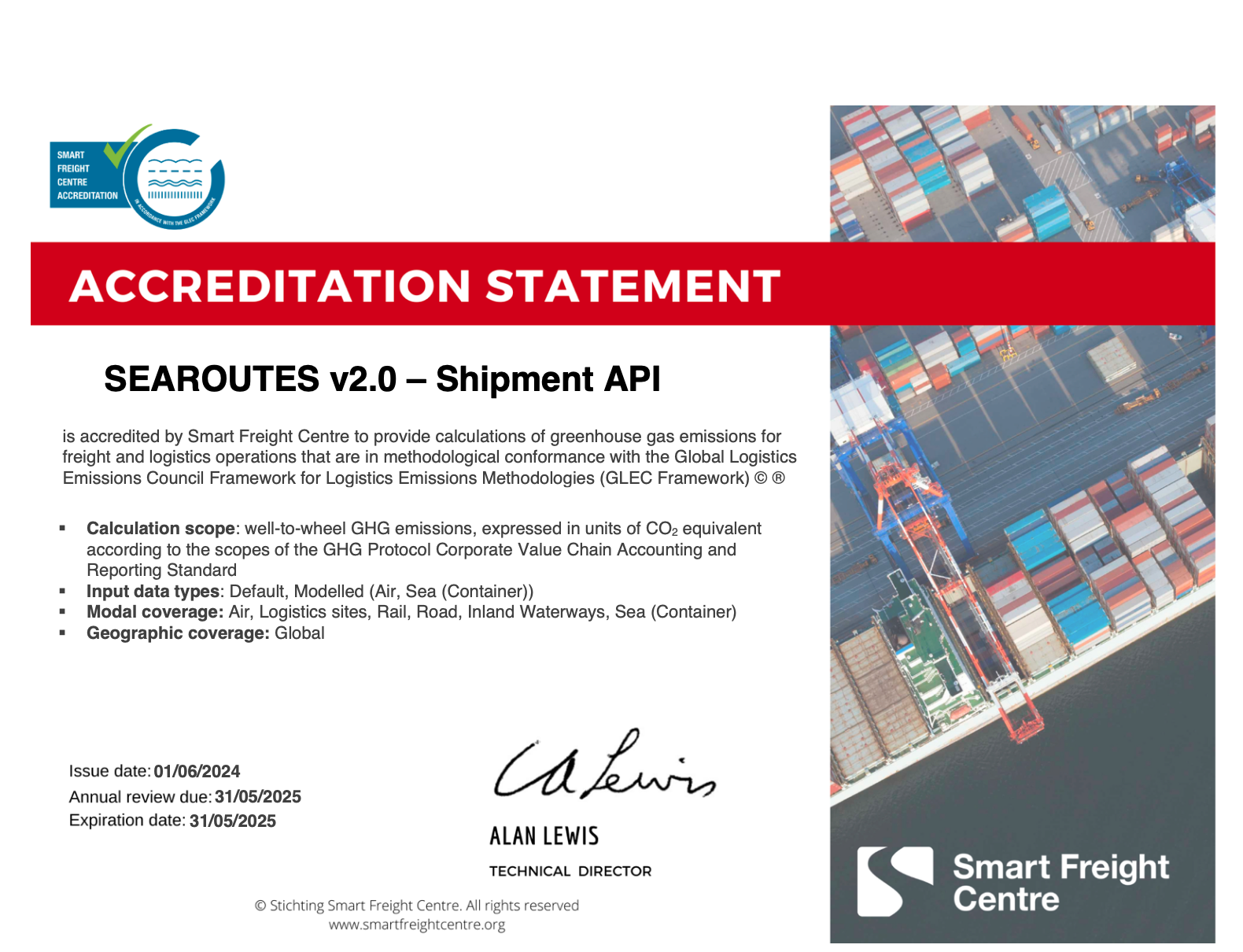
Our methodology is accredited by the Smart Freight Centre.
At Searoutes, we want CO2e emissions estimation to be accessible quickly to the different stakeholders of the logistics, so it's easy to integrate into decision making. We are compliant with the GLEC Framework, which allows us to accurately measure and report CO2e emissions of Carriers, Freight Forwarders and Shippers.
At Searoutes, we believe logistics could become one of the main polluters in the near future, as the GLEC Framework puts it:
Comprising 23% of global greenhouse gas (GHG) emissions, the transport sector is the third largest source of GHG emissions after industry and buildings. Freight transportation made up 36% of transport’s emissions in 2015, but is expected to be at least equivalent to passenger transport by 2050. [...] Without intervention, freight transport emissions will more than double by 2050.
Our modeling currently supports the following modes and regions:
| 🚢 SEA | ✈️ AIR | 🚚 ROAD | 🚄 RAIL | 🛥️ INLAND WATERS | |
|---|---|---|---|---|---|
| SFC Accredited | ✅ | ✅ | ✅ | ✅ | ✅ |
| Data Source | Modelled & Default Data | Modelled & Default Data | Default Data | Default Data | Default Data |
| Asset Coverage | + 10,000 Vessels | +40 Airplanes | 12 Trucks categories | 7 vessels types | |
| Distances | Routes based on AIS | Great Circle | Road network | Open Rail Map | Routes based on AIS |
| Regions Coverage | World* | World* | World* | World* | Europe, North America, China |
| Fuel Types | HFO, VLSFO, ULSFO, MDO, MGO, LNG, BIOLNG, LSMGO, Methanol, Biomethanol, IFO380, UCO, Methanol Coal, Methanol Gas, Methanol renewables. | Diesel, CNG, LNG, HVO, Electric, BioLNG, BioCNG, Biodiesel and its multiple blends. | Diesel, Electric | Diesel | |
| 🍶 Searoutes' Special Sauce | Actual vessel trajectories, distances and speeds, passages & ECA zones, IMO-specific, vessel engine specific | All flight phases, Aircraft IATA specific | Seamless integration of the location of cities, zip codes and addresses | Seamless integration of the location of cities, rail terminals and addresses | Actual distances and draft restrictions |
*some modes are using different emission factors according to the region.
Philosophy
Following GLEC's guidance, Searoutes' APIs estimate CO2e which is the common unit used to represent the global warming impact of the various Green House Gases. The estimations of our CO2e are indirect emissions from the reporting company’s supply chain. This includes transportation emissions required to move goods from suppliers to the reporting company and from the reporting company to the end customer. In other words, Searoutes' APIs encompass Scope 3 emissions, as defined by the Greenhouse Gas Protocol.
Further, our estimations include the full fuel life cycle, comprised of well-to-tank (WTT), the emissions to extract, produce and deliver energy, and tank-to-wheel (TTW), the emissions caused to move the vehicle.
Searoutes' approach to CO2e calculations is to make use of the most granular data possible for estimations, and expose an easy to use API.
| Data Input | 🚢 SEA | ✈️ AIR | 🚚 ROAD | 🚄 RAIL | 🛥️ INLAND WATERS |
|---|---|---|---|---|---|
| Required | From, To* | From, To* | From, To* | From, To* | From, To* |
| Optional | Date, Vessel IMO or name, Carrier scac, # Containers, container sizes and types, Load Weight, Fuel type | Aircraft IATA Code, Load Weight | Fuel Type, Truck Size, # Containers, container sizes and types, Load Weight | Fuel Type, # Containers, container sizes and types, Load Weight | Barge Type, # Containers, container sizes and types, Load Weight |
*(UNLOCODE or coordinates)
Partners
The following partners help us enrich and distribute CO2e data. They help us make it more accessible to the different stakeholders of the logistics.
Main references
Our main references for the methodology below include:
- GLEC Framework version 3 (2023).
- Third / Fourth IMO Greenhouse Gas Study 2020;
- EMEP/EEA air pollutant emission inventory guidebook 2019
Updated 3 months ago